Program 1 Sustainability Of Natural Resources
Program Leader:
Dr Liz Humphreys
CSIRO Land and Water
Griffith
The past 12 months have been a very intense but exciting period of growth, new developments, consolidation and networking (at regional and international levels) for Program 1. In particular, several new key appointments have enabled projects which were previously on hold or in a low state of activity to swing into full action. With the appointments of Drs Shahbaz Khan and Kaye Spark as leaders of the groundwater and water quality Sub-Programs, Program 1 is now well-positioned to make significant advances towards the sustainable management of natural resources for irrigated agriculture in the rice growing regions of southern Australia.
Both the on-farm natural resource base and the wider environment are susceptible to degradation by irrigated agriculture. The regional and national importance of the rice industry, and the long-term ponding of irrigation water for rice culture present unique challenges to management for environmental and economic sustainability. These challenges include rising watertables leading to waterlogging and root zone salinisation, contamination of surface and groundwaters by irrigation drainage, and degradation of river, riparian and floodplain ecosystems due to altered water regimes.
Research in Program 1 is directed towards:-
while maintaining or increasing profitability.
This will be achieved through the application of new knowledge, technologies and tools developed by Program 1, including:-
Sub-Program Leader:
Mr Geoff Beecher
NSW Agriculture
Yanco
Improved land use capability assessment techniques are needed to enable farm planning to minimise groundwater recharge from rice fields, channels and drains.
Tools are required that provide better measurement, in space and time, of factors critical in managing rice-based farming systems. Better remote sensing tools are required for monitoring crop areas and types, and for identification of groundwater recharge sites.
The aim of the Sub-Program is to develop tools to increase natural resource use efficiencies by developing better land use mapping and water use measurement techniques.
Better prediction of groundwater recharge from ricegrowing (1102)
Project Leader:
Mr Geoff Beecher
NSW Agriculture
Yanco
Lower groundwater recharge is essential for sustainable irrigation farming in southern Australia.
A significant outcome from previous work on rice land suitability assessment was the adoption of electromagnetic induction (EM31) surveying of rice fields to identify soil assessment sites. Application of this approach has highlighted questions about the appropriateness of the soil textural criteria for rice land suitability assessment over all soil types. Findings from RIRDC Project DAN145A suggest that sodicity has a very important role in recharge from rice growing.
This project aims to improve rice land classification by including soil physico-chemical and landscape attributes in the classification scheme.
Progress
We are currently investigating two areas focusing on soil sodicity:
a. Can we quantitatively assess soil sodicity levels successfully with in-field approaches?
In the current rice land approval process, soil texture is assessed in the field and rice land suitability classifications are based on these assessments. This project is investigating the possible use of quantitative field sodicity assessment methods that could be related to a rice land classification process based on EM and ESP assessments as proposed in previous studies. Soil sodicity is being measured using a range of methods including the saturation extract sodium adsorption ratio (SARe), the 1:5 soil water extract SAR1:5, the Rengasamy jar test, the Horibie sodium Cardy meter and the Hach field sodicity kit. Results from the Hach field sodicity kit have been disappointing with kit estimates of sodicity levels significantly lower than estimates from other methods. Discussions with Prof Jim Oster (University of California) have led to the suggestion that these differences may be due to the junction potential affecting the electrode reading directly in the saturated soil paste. The exact reason for this under-estimation is being investigated with staff at the US Salinity Laboratory. At present the Hach field sodicity kit appears to be unable to estimate soil sodicity in our soils.
b. Can we use in-field classes derived from EM31 maps of rice fields to effectively estimate spatial changes in sodicity across these rice fields?
In this project we are examining field scale variability in sodicity in relation to sampling sites identified using the EM31 surveys. Six rice fields have been intensively sampled to 150cm depth at sites selected on the basis of EM readings. Soil sodicity measurements undertaken on samples from individual fields so far suggest that differences in soil sodicity levels occur between EM classes and that there is the opportunity to classify the rice field on this basis. This provides encouragement that field variation in sodicity can be mapped and could prove useful in allowing a more robust assessment of land that should be used for rice growing allowing a minimal groundwater recharge component.
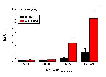 Figure 2. Variation of depth weighted averages of SAR1:5 in the (0-60cm) and (60-150cm) depth intervals in the different EM-31v (ECa mS/m) classes for RBE (red brown earth) soils in the MIA area.
|
Dr Neel Jinadasa (Project 1102) |
Measurement of losses from on-farm channels and drains (1104)
Project Leader:
Mr Saud Akbar
NSW Agriculture
Yanco
The aims of this project are to monitor seepage (distribution and amount) in old and new on-farm channels and drains, and to use EM surveys to identify seepage sites.
Progress
Seepage investigations were carried out within selected farms in the Coleambally and Murrumbidgee Irrigation Areas in southern NSW during the irrigation seasons of 1997/1998, 1998/1999 and 1999/2000. The Idaho Seepage Meter was used to make point infiltration measurements.
Seepage was only estimated for those channels and drains being used by the landholder in the periods seepage measurements were taken, and only permanent structures were investigated. Only three of the nine farms investigated were using all of the channels and drains on the farm during monitoring activities. This may cause the annual seepage losses calculated per farm to be underestimated.
Seepage losses were generally much higher in new channels. The low seepage results from 15-to 30-year-old channels may be due to biological activity and sediment deposition which was observed on the channel beds but not on the entire wetted perimeter of the channel. Some old channels, which were cleaned prior to the irrigation season, had significant seepage volumes.
In new channels and drains low seepage rates were also found at many sites. These sites could have been influenced by factors such as compaction beneath the bed of the channel, soil sodicity, biological activity, and silt deposition on the channel bed.
Methods of identifying the extent and likely magnitude of potentially high seepage loss sites along channel and drainage lines need to be developed. EM31 surveys were used to characterise soil differences along channel and drainage lines and the apparent electrical conductivity (ECa) values were compared with the direct seepage measurements. This method successfully identified actual seepage sites, and the results suggest that it is a useful tool for initial investigations to identify seepage sites.
The highest seepage rates were found where ECa values were low. However, seepage rates were also low at some sites with low ECa values, which may be due to factors such as compaction of the channel bed, the type and thickness of clay layers below the bed, sodicity, biological activity and sediment deposition.
Remote sensing of crop types and crop area measurement (1105)
Project Leader:
Mr Tim McVicar
CSIRO Land and Water
Canberra
The aim of this project is to use readily available regional remotely sensed data to map different crop types and to assess their application for regional water use efficiency estimation.
Progress
Mr Tom van Niel, 100% funded by the CRC, was appointed in January 2000 to CSIRO Land and Water Canberra, as an Environmental Spatial Modeller to work on Project 1105 for three years.
A draft literature review was presented to irrigation company environmental officers and spatial data technical staff during a visit to the rice growing regions in March. This has progressed since then and is on track for finalisation by June 2000.
Several potential advances in the application of remote sensing technology are currently being investigated. They include: testing methods to temporally normalise a time series of remotely sensed data; exploring the utility of night time thermal data for mapping cold air temperature damage; combining current fine vector data with prospectively acquired coarse raster data to accurately assess rice growing areas at reduced cost.
Sub-Program Leader:
Dr Liz Humphreys
CSIRO Land and Water
Griffith
Net recharge management involves reducing recharge to and increasing discharge from watertables.
Projects are in progress that will:-
Optimising agronomic options at the farm scale (1201)
Project Leader:
Dr Shahbaz Khan
CSIRO Land and Water
Griffith
The project aims to develop a farm scale hydrologic economic model that will:-
Progress
Data on crops, soils, water allocations, groundwater use, groundwater conditions and farm layouts have been collected for 14 representative farms in the Murray irrigation area for further application of the SWAGMAN Farm model. SWAGMAN Farm was also applied to selected farms in the Coleambally Irrigation Area as part of the Land and Water Management Plan. Both simulation (physical and economic runs for specified land uses) and optimisation (optimum land uses determined by model on the basis of specified land uses) runs were carried out. The sensitivity of net recharge and root zone salinisation to variations in a range of factors was analysed. Factors varied in the sensitivity analyses included:-
These sensitivity runs have helped to identify model weaknesses leading to improved representation of biophysical processes. Data collected in the "Crops after rice" Project (1205) were used to incorporate concepts of soil water content changes under different cropping systems. This improvement has enhanced the model's capability to predict changes in watertable depths and soil salinity in a rational manner.
SWAGMAN Farm biophysical processes are being further improved using intensive paddock monitoring data through a Murray Irrigation/LWWRDC/CSIRO project and distributed hydrological models such as the US Soil Salinity Laboratory model Hydrus 2-D and CSIRO's SWAGSIM. A representative farm scale SWAGSIM model has been developed to understand the interaction of crop rotations, watertables, recharge, salinity and capillary upflow under different land uses.
The previous version of the SWAGMAN Farm model required specialised and costly software (GAMS) to run optimisation scenarios. For wider application of SWAGMAN Farm with GIS databases a GAMS-independent linear programming module has been written to enable model optimisation. The salt and water balance processes have been coded in C++ language. A customised Microsoft Access database has been developed and linked with the object oriented model. The new model code has been tested to determine the suitability of optimisation routines and linking to the GIS database.
Arc View based GIS databases of the Coleambally and Murray irrigation areas are currently being customised for linking to SWAGMAN Farm. This will allow wider application of SWAGMAN Farm for the development of environmental management policy options.
|
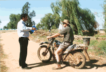
Dr Shahbaz Khan discussing on-farm management with a farmer |
Improving the water use efficiency of rice (1204)
Project Leader:
Mr John Thompson
NSW Agriculture
Deniliquin
The project aims to investigate opportunities to improve the water use efficiency of the rice crop by comparing the raised bed layout with conventional aerial sowing. The effect of short season varieties is also being investigated.
Progress
In 1999/2000, a replicated field experiment on a cracking grey clay compared rice growth and water use of aerially sown rice grown under three management regimes: (i) conventional aerial sowing, (ii) raised bed layout with water in furrows all season, and (iii) raised bed layout with "deep" water from panicle initiation. The variety Opus was sown on 31 October, 1999. Yield from the raised bed layout where water was maintained in the furrows all season was reduced by 11%. Preliminary figures indicate that water use was reduced by 18%, a larger reduction than measured on a red-brown earth in the two preceding seasons. A further experiment on this cracking clay soil type is planned for 2000/2001.
Quantifying and maximising the benefits of crops after rice (1205)
Project Leader:
Dr Liz Humphreys
CSIRO Land and Water
Griffith
The project aims to:-
o constraints to growing crops/pastures immediately after rice;
o actors leading to successful production of crops after rice;
o impacts on sustainability (environmental, economic); and
o crop water use and its source (rainfall, stored soil water, upflow from the watertable);
o net recharge of the watertable;
o distribution of salt in the root zone; and
o productivity and water use efficiency of the rice-wheat cropping system.
Progress
Replicated field experiments were installed on a Beelbangera clay loam (1998, 1999) and on a Willbriggie clay loam (1999, 2000) to compare the effects on components of the water balance of: (i) stubble retained fallow, and (ii) wheat direct drilled after burning the rice stubble. Crop growth, piezometric pressures at different depths, perched watertables at two metres, volumetric soil water content and soil matric potential were monitored regularly. Microlysimeters were installed in 1999 to directly determine evaporation in the fallow treatments. Soil hydraulic properties at both sites were determined in early 2000 using slug tests and pump tests in the piezometers and test wells.
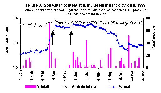
On the Beelbangera clay loam vigorous growth was achieved, with total dry matter production peaking at over 16 t/ha in both years. The crop dried the soil profile (Figure 3) and lowered the watertable compared with the fallow treatment in both years. Preliminary lumped water balance calculations suggest significantly more recharge in the stubble-retained fallow compared with the planted treatment in 1998.
Crop growth on the Willbriggie clay loam was impaired in 1999 due to the later sowing, waterlogging during establishment, and severe rust infestation during the second half of the season. Dry matter production peaked at about 10 t/ha. The effect of the crop on drying the soil profile was not as pronounced as on the Beelbangera soil, and there was no effect on the depth to the watertable.
Future research will concentrate on calculation of the soil water fluxes, and analysis of the influence of regional groundwater pressures and lateral flows between the treatments on the depth to the watertable.
Using models to quantify the benefits of wheat after rice (1206)
Project Leader:
Dr Liz Humphreys
CSIRO Land and Water
Griffith
The aims of the project are to:-
Progress
A draft literature review on rice-wheat cropping systems has been prepared. Six southern NSW irrigated and non-irrigated wheat data sets were compiled and used to calibrate and validate the CERES Wheat and SWAGMAN Destiny models. Model refinement and validation are complete. Validation was accomplished by modifying the genetic coefficients of the varieties to match the observed flowering and maturity dates. The modified genetic coefficients were then applied to independent data sets for model validation. The ability of the models to simulate crop growth over time (biomass, leaf area index, root length density), yield, evapotranspiration, soil water content and depth to the watertable (only available in Destiny) was remarkably good.
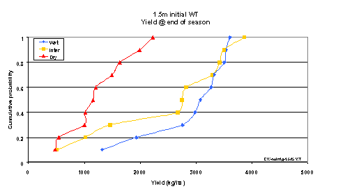
Simulations have been completed for early and late sown wheat crops and fallow after rice using SWAGMAN Destiny (Figure 4) to investigate the tradeoffs between yield, root zone salinity and watertable management. For example, Destiny predicts that non-irrigated wheat sown after rice will almost always lower the watertable, regardless of seasonal conditions, starting watertable depth (for starting depths within about 1.5m of the soil surface) and salinity and sowing date. The model also predicts that in the absence of irrigation, earlier sowing produces higher yields than late sowing, whereas with unlimited irrigation similar yields are achieved for crops sown in late April and late June. In the absence of irrigation, the highest yields are achieved where there is a shallow (0.5m), fresh (1 dS/m) watertable present at the time of sowing. Figure 4 shows that with an initial watertable depth of 1.5m and low salinity (1 dS/m), yields of non-irrigated wheat sown after rice harvest in late April will range between 1.3 and 3.6 t/ha (wet line) depending on seasonal conditions, but that in 60% of years, yields will exceed 2.8 t/ha. With irrigation to avoid water deficit, yields of 5-6 t/ha are achieved for both sowing dates, regardless of initial watertable conditions.
Figure 4. Simulated wheat yields for 10 years of climatic data, with initial watertable depth 1.5m and salinity 1 dS/m, no irrigation, and initial dry, wet or intermediate soil water content. For wheat sown after rice, the soil will be fairly wet (wet line).
Sub-Program Leader:
Dr Kaye Spark
CSIRO Land and Water
Griffith
Surface drainage management involves quantity and quality aspects. Salt, suspended sediments (turbidity), nutrients and agrochemicals are major pollutants in surface drainage waters. These pollutants can be arrested by reuse of drainage water for irrigation, or by managing them in holding ponds, evaporation basins, wetlands etc. Research is required to determine appropriate management options and design criteria for the range of drainage conditions that exist on rice farms.
Bioremediation of pesticide residues in irrigation drainage waters (1303)
Project Leader:
Dr John Oakeshott
CSIRO Entomology
Canberra
This is a PhD project being undertaken by Ms Rama Heidari. The study forms part of a larger project to develop an enzymatic bioremediation technology for cleaning up pesticide residues in irrigation tail waters and on horticultural commodities.
Progress
Of particular interest to the rice industry are the herbicides molinate, thiobencarb (thiocarbamates), atrazine and glyphosate, and the insecticides chlorpyriphos (thion organophosphate) and endosulfan. The project is concentrating in the first instance on the degradation of pesticidal esters (organophosphates, carbamates and pyrethroids), building on prior studies involving the oxon organophosphate (OP) hydrolytic activity of an esterase enzyme (esterase E3) that was isolated from OP resistant blowflies. Endosulfan is also being targeted at the particular request of the cotton industry.
The laboratory has produced a series of E3 and EST23 (Drosophila orthologue of E3) mutants, using in vitro mutagenesis techniques, in the hope of improving the activity of the enzyme for oxon OPs and/or extending its activity to include thion OPs (eg chlorpyriphos) and other pesticidal esters. Ms Heidari's preliminary analyses of the first eight of these mutants using a radiometric partition assay for pyrethroid hydrolysis revealed that five of the mutants hydrolysed permethrin. The arrival in August 1999 of Prof Alan Devonshire, who is a world leader in pesticide enzymology, saw improvements in both the enzyme titration procedure and the pyrethroid assay. Specificity constants (kcat/Km) can now be calculated accurately for each of the enzymes with permethrin activity, allowing direct comparison of the enzymes.
About six different pyrethroid formulations are used commercially, and in all cases except one these formulations comprise multiple isomeric forms. It is therefore important to determine if the enzymes can hydrolyse all isomeric forms. Radiolabelled permethrin has now been separated into pairs of cis and trans isomers using thin layer chromatography and the enzymes tested for hydrolysis of each isomer pair. Interestingly, both cis and trans isomers were hydrolysed, although only one of the enantiomers in each pair was hydrolysed rapidly.
Assays have now been developed in the laboratory for the hydrolysis of carbaryl (carbamate insecticide), thiobencarb (thiocarbamate herbicide), coumaphos and parathion (thion OPs) and endosulfan. Ms Heidari will assay the suite of mutants for possible hydrolytic activities using these substrates.
|
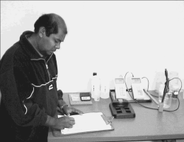
PhD student, Ms Rama Heidari, performing pesticide hydrolysis assays at her laboratory bench at CSIRO Entomology, Canberra |
Sub-Program Leader:
Dr Shahbaz Khan
CSIRO Land and Water
Griffith
The aim of this Sub-Program is to develop tools and guidelines which can be used to manage shallow watertables and soil salinity. The tools developed under these projects will be able to represent complex interaction of climate, irrigation, crops and soils with the groundwater dynamics and salt movements at paddock, farm and regional scales. The specific goals are:-
Estimation of salt transport and salinisation in rice-based irrigation areas (1401)
Project Leader:
Mr Charles Demetriou
NSW Department of Land and Water Conservation
Parramatta
The aim of the project is to develop guidelines which will promote the use and management of acceptable quality groundwater in both farm and large scales.
The outcomes of the project will be:-
The project has been split up into the following two sub-projects.
Salt transport at the regional scale (1401a)
Project Leader:
Dr Yaping Shao
University of New South Wales
Sydney
The aim of this sub-project is to develop an integrated modelling system which will consist of an atmospheric model, a land-surface model (including a salt module) and a groundwater model for the simulation of salinisation and the estimate of salt transport and salt balance on regional scales. The integrated model will be tested and partially verified using data for the Wakool Catchment.
Progress
Mr Peng Xu is the PhD student working on this project which commenced in August 1998. The following progress has been made: -
1. The coupling of the atmospheric model, the land-surface model (ALSIS) and the groundwater model (MODFLOW) has been completed. With HIRES' high spatial resolution atmospheric data (10km), the simulation of soil moisture and surface water runoff and hence the transport of salt on regional scales is now possible. A long-term integration of the system allows the development of scenarios of salt accumulation and transport over the landscape. The predictions of soil moisture over the Australian continent have been accomplished with reasonable success.
2. The development of a new salt solute transport model for the unsaturated zone has been completed and this has been tested and coupled into the existing land-surface scheme, ALSIS. The development of the salt module is essential to the project. It is important to emphasise that the functioning of the salt solute transport would not have been possible without the modelling of soil water balance.
3. The coupled system has been applied to the Wakool Irrigation Catchment for the simulation of soil moisture, salt solute transport and groundwater flow. The preliminary results show that the functioning of the system is as expected.
4. A considerable effort has been devoted to the development of a new dynamic-statistic surface runoff model, which is key to the simulation of salt transport on regional scales. The theoretical framework of the new runoff model has been established. The new theory is being programmed and tested.
Modelling and optimisation of groundwater dynamics adjacent to a rice paddock (1401b)
Project Leader:
Mr Noel Merrick
National Centre for Groundwater Management
University of Technology, Sydney
The aims of this sub-project are:-
Progress
Ms Megan McLachlan is the first MSc student working on this project. The following progress has been made:-
Quantifying climatic and management impacts on shallow watertables and soil salinity (1403)
Project Leader:
Dr Shahbaz Khan
CSIRO Land and Water
Griffith
The aim of this project is to develop regional groundwater flow and solute transport models of rice-based irrigation areas which can help differentiate climatic and management impacts on watertables and soil salinity. Application of these models will enable development of guidelines for effective implementation of Land and Water Management Plans.
Progress
1. Further improvement of the Coleambally groundwater model
2. Murrumbidgee groundwater model
3. Water balance modelling
In collaboration with the "Crops after Rice" Project (1205) and the Chinese Academy of Sciences, progress has been made to develop generalised models which can quantify fluxes under unsaturated soil conditions. The following methods have been programmed to analyse field data:-
4. Climatic variability analysis and relationships with watertable response
To look into the seasonal variability of rainfall "Standard Precipitation Indices (SPI)" have been computed. This is a state-of-the-art method for assessing climatic variability developed at the Colorado Climate Centre, USA. SPI is based on statistical techniques which quantify degree of wetness by comparing 3, 6, 12 or 24-monthly rainfalls with the historical rainfall data from the same periods. For example, a six-monthly SPI for August 1999 will compare the March 1999 to August 1999 rainfall totals with the historic totals for the March to August period. The six-monthly August SPIs for Griffith, Finley and Coleambally (Figure 5), show that last 10 years have been close to normal or dry winter rainfalls. This partly explains the lowering of watertables in some irrigation areas in recent years. For example, Figure 6 shows strong correlation between SPI and changes in the depth to the watertable in the Murray Valley. SPI will be used to help us identify sequences of wet and dry rainfall years. These wet and dry rainfall sequences will then be simulated in groundwater models to differentiate and quantify climatic and management impacts on watertables.
Figure 5. Variability of Winter Rainfalls
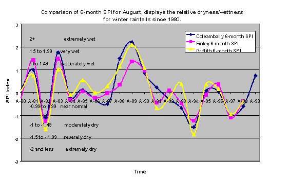
Figure 6. Piezometric Fluctuations and Standard Precipitation Index for Finley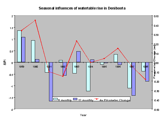
Risk-based spatial modelling to identify regional soil salinity trends in irrigation areas (1403b)
Project Leader:
Dr Shahbaz Khan
CSIRO Land and Water
Griffith
Conventional salinity analysis techniques assume average parameters to forecast spatial and temporal trends of soil salinity in irrigated areas and therefore fail to provide comprehensive understanding of mechanisms and best management practices. This PhD project aims to improve integrated surface and groundwater models such as SWAGSIM by incorporating stochastic (parametric uncertainty and spatial variability) and risk-based salinity assessment techniques. These models will be used in association with GIS-based salinity risk assessment protocols to analyse and predict temporal and spatial trends of salinity considering variation of surface features, soils, crops, climate, watertables and hydrology of irrigated catchments under different Land and Water Management Plan scenarios.
The expected outcomes of this project are:-
Progress
The research proposal has been finalised. The PhD studentship has been advertised and research is expected to start in July, 2000.
Milestones
Milestone |
Year 1 |
Year 2 |
Year 3 1999/2000 |
Year 4 |
Year 5 |
Year 6 |
Year 7 | |
1.1 |
Measurement and mapping |
|||||||
Measurement of soil suitability |
X RIRDC project |
|||||||
Better prediction of groundwater recharge |
||||||||
- review indices of recharge |
X _ |
X _ |
||||||
- experiments |
X _ |
X _ |
||||||
- data collection |
X _ |
X _ |
||||||
- reporting |
X _ |
X |
||||||
Water management practices on irrigation farms |
||||||||
- evaluating water management practices |
X Deferred |
X Not CRC - external funding (from LWRRDC) being sought by CSIRO Land and Water |
X _Funds acquired from LWRRDC starting January 2000 to enhance existing monitoring project being undertaken by Murray Irrigation with CSIRO Land & Water |
|||||
Losses from farm channels |
X Commenced |
X _ |
X _ |
|||||
Remote sensing of crop types |
||||||||
- appoint student |
X Not Achieved |
Not achieved |
Unable to locate suitable student. Project scientist appointed, commenced January 2000. |
|||||
- review current methods |
X Not commenced |
_ |
||||||
- collect existing data |
X Not commenced |
X Not commenced |
||||||
- develop and test methods |
X |
|||||||
- complete project |
X |
X |
||||||
Classification of irrigated soils by remote sensing |
||||||||
- review |
X _ |
X _ |
) This project will |
|||||
- acquire and compile existing data |
X Deferred |
X Deferred |
X ) not proceed |
|||||
- conduct research to fill gaps |
X Not commenced |
X ) |
||||||
- develop derivative classification maps |
) |
|||||||
- integrate technology with existing data systems |
) |
|||||||
1.2 |
Net recharge management |
|||||||
On-farm agronomic options |
||||||||
- model testing and refining |
X Commenced |
X _ |
X _ |
X |
||||
- economic model developed |
X Commenced |
X _ |
||||||
- options assessed |
X Commenced |
X _ |
X _ |
X |
||||
Improved soil salinity assessment and prediction model |
||||||||
- model testing and refinement |
X _ |
X _ |
||||||
Hydraulic loading policy assessment |
||||||||
- hydraulic loading review |
X) Not commenced. To |
X ) |
||||||
- available models reviewed |
X) be transferred to Sub-Prog. 1.4 |
) Transferred to Project 1403 ) |
||||||
- development and application of new models |
X ) |
|||||||
Improved water use efficiency |
||||||||
- field trials complete |
X _ |
X _ |
X _ |
X |
||||
Crops following rice |
||||||||
- survey |
X _ |
X _ |
||||||
- field monitoring/trials |
X _ |
X _ |
X _ |
X |
||||
- review/modelling |
X _ |
X _ |
||||||
- alternative crops |
X |
X |
X |
X | ||||
Compaction options |
||||||||
- project evaluation |
X _ |
|||||||
- alternative techniques assessed |
X No further work proposed |
|||||||
1.3 |
Surface drainage management |
|||||||
Appointment of staff |
X Deferred |
Partly achieved |
Partly achieved |
|||||
Downstream impacts on the environment |
||||||||
- biodiversity survey completed |
X Commenced in Program 2.4 |
X Deferred |
||||||
- development of techniques to minimise pollutants |
X Not achieved |
X |
X |
X |
X | |||
On-farm management options |
||||||||
- desktop study completed |
X Deferred |
X Deferred |
X Partly achieved |
|||||
- field trials to assess technology |
X Deferred |
X Not achieved |
X |
|||||
- FILTER technology assessed |
X Commenced |
X _ |
||||||
- DSS system developed |
X Not achieved |
X |
X |
X |
X | |||
Regional management options |
||||||||
- redundancy of measures defined |
X Partially commenced |
X Partially commenced |
Not achieved |
|||||
- region wide options defined |
X Not achieved |
X |
X |
X |
X | |||
Smarter farming systems |
||||||||
- residual toxicity definition |
X Partially commenced |
X Continuing |
Not achieved |
|||||
- rapid tests developed |
X Partly achieved in non-CRC project at CSIRO Land & Water Griffith |
X |
X |
X |
X | |||
- farming system proposals |
X Not achieved |
X |
X |
X |
X | |||
- developed and extended |
||||||||
1.4 |
Groundwater management at the regional scale |
|||||||
Estimation of salt transport and salinisation |
||||||||
- recharge estimation and mapping |
X Commenced |
X Continuing |
X Continuing |
|||||
- transport models |
X Commenced |
X Continuing |
X Continuing |
X |
||||
- nutrient export and management |
X Continuing |
X Not applicable |
X |
|||||
Managing groundwater systems |
||||||||
- shallow groundwater pumping options |
X Commenced |
X Continuing |
X Continuing |
X |
||||
- deep groundwater pumping options |
X Commenced |
X Continuing |
X Continuing |
X |
X |
X |
||
Management model to assist reform |
||||||||
- allocation strategies optimised |
X Continuing |
X Not applicable |
||||||
- integrated surface and groundwater models developed |
X Commenced |
X Continuing |
X Continuing |
X |
X |
X |
X | |
- salt and nutrient strategies included in models |
X Continuing |
X Continuing - salt only at this stage |
X |
X |
X |
X |
X = To be completed (in some cases this exercise is spread over several years).
_= Achieved (if not achieved, status provided)