


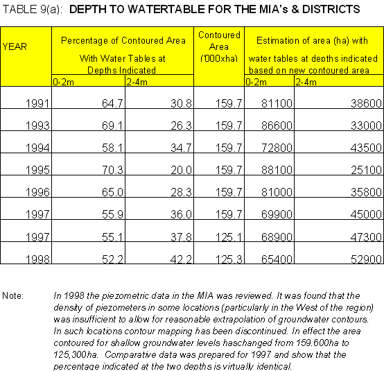
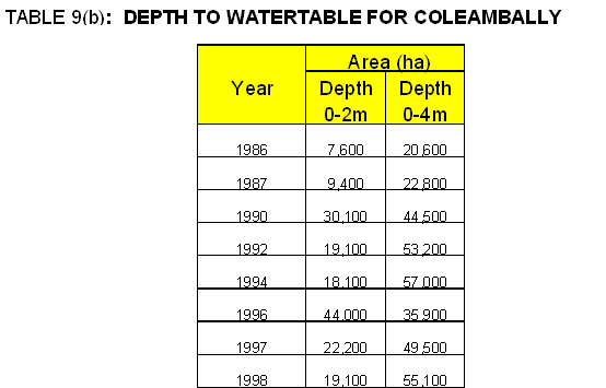
Large parts of the irrigation Areas and Districts are underlain by shallow watertables. Tables 9(a) to 9(f) present data on areas at particular Watertable depths. (Note that along the river the intensity of irrigation carried out by licensed diverters is less and shallow groundwater is unlikely to be a problem. Whilst the DLWC has some piezometers this aspect is not monitored as it is not deemed necessary.1)
In all regions the data shows that in recent years there has been a decrease in areas with groundwater levels in the 0-2 metre range.
There are a number of reasons suggested for this decrease. These include drier climatic conditions in 1997 and 1998, better identification and isolation of leaky paddocks and improved water management practices adopted by landholders to reduce recharge.
Despite the recent favourable trends with water table levels the prevailing view remains that in the long term the areas underlain by shallow water tables will continue to increase. For instance it has been estimated that by 2020 the area of water table at depth 0-2 metre in the Berriquin and Denimein Irrigation Districts would reach 200,000 ha, up from the 1998 level of 44,124 ha.
Whether such an expansion of shallow water tables will result in a significant decline in production potential will depend on the salinity and sodicity levels of the groundwater, the extent to which irrigation activities can be used to successfully leach the top soil, and whether or not groundwater and salinity extraction works are implemented. In relation to using irrigation to leach topsoil, growing rice can be an important tool, because flooding the soil ensures that leaching occurs. In areas where degradation is occurring it is possible for rice to be used as a pioneer crop with the leaching of the topsoil improving the production potential of following crops.
The Land and Water Management Plans focus significantly on reducing accessions to the groundwater. Issues generally addressed by all of the Plans include: -
The extent to which the principles of the LWMP's have been embraced by all participants and put into practice has exceeded expectations. It is important that this impetus is maintained, particularly in a period when farm incomes are under pressure because water supplied has actually been reduced (because of dry seasons) and where further reductions are threatened because of potential government action.
Irrigation activity is a net importer of salt. Even through the water supply is of high quality, large quantities are used, and as drainage flows of water (and salt) back into the rivers are substantially avoided, salt is transported into the soil profile and into groundwater.
Net imports of salt in 1997/98 are as follows: -
MIA's and Districts |
100,000t |
Coleambally |
49,000t |
Murray Valley |
32,000t |
However provided this salt can be leached out into the Watertable then there may not be a deleterious effect on production, unless watertables are so close to the surface that waterlogging is caused.
The recently published Salinity Audit indicates that mainly because of clearing in the catchments of the river valleys that salt is rapidly being mobilised in the catchments. This will result in increases in the salinity levels of irrigation water supply.
For the Murrumbidgee it is estimated that average river salinity at Wagga Wagga will rise from the 1998 level of 140EC to 190EC in 2050. By extrapolation this suggests that if current irrigation operations regarding drainage water and salinity returns to the river are maintained the salt retained in the MIA's and Districts and Coleambally will rise from the 1998 level of 149,000t to about 200,000t in 2050.
In the Murray Districts salinity levels in the water supply are not expected to increase significantly as inflows above Albury are very fresh and supplemented with good quality water through the Snowy Mountains Scheme.
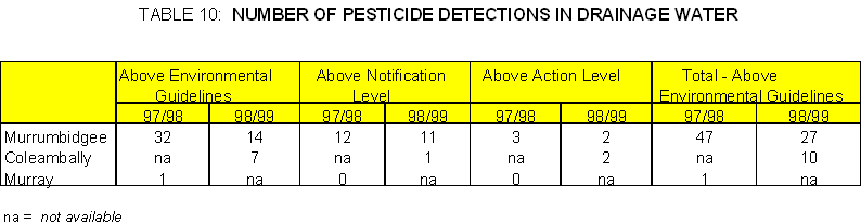
It is a requirement of the Pollution Control Licenses held by the irrigation corporations that the level of certain agricultural chemicals is monitored. For each pesticide instances of levels above environmental guidelines, notification and action levels are recorded. For notification and action level occurrences appropriate actions are required to be taken.
Detections are summarised in Table 10.
Generally the level of recording detections is regarded as low and appears to be declining. This is attributed to active education programs conducted by all the corporations and improved farm layout and on-farm practices.
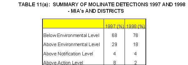
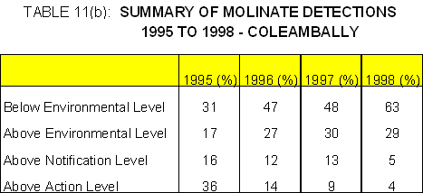
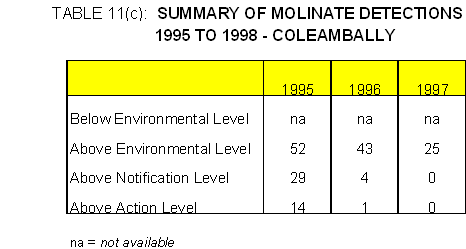
Molinate is used extensively in the rice industry for weed control. As a requirement of the Pollution Control Licenses the irrigation corporations monitor the level of molinate at key points in the irrigation supply and drainage systems during the period October to December each year.
Summary data are shown in Tables 11(a), 11(b) and 11(c).
The data suggests an improving situation with a marked decline in recordings above notification and action levels.
1 Department of Land & Water Conservation does not agree with this statement.
2 Department of Land & Water Conservation believes this option has very limited potential.
