|
[Front Page] [Features] [Departments] [Society Home] [Subscribe]

Between Jerusalem and the Acropolis
Harry Loots
Rain has made the highlands of Tasmania into a natural wonder. Highland plants, rivers, lakes and peats are a result of the usually wet climate. Rain, wet days, wet nights has been the Tasmanian experience. I prepared for our (ie. Lindy and myself) January 1998 bushwalk by waterproofing the tent and my rain jacket. Lindy, my companion, spent a small fortune buying a new rain jacket. However, this time instead of being soaked most of the time we suffered from sunburn and some heat exhaustion.
In January 1998 Tasmania suffered a severe El Nino induced drought. We enjoyed ten mostly dry days walking between the Walls of Jerusalem and Lake St. Clair on the Central Plateau of Tasmania. Much of the usually soggy squelchy black peat had dried out. Our boots were dry. This was more pleasant than our usual experience of putting cold heavy wet boots onto cold feet in the mornings. Finding water, in this drought, was not a problem as our path led us past lakes and streams. The refreshing water was always cool and pure and there were plenty of opportunities for a swim.
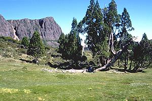
We crossed a land called the Lake Country. It has over 4,000 lakes. Between 20,000 and 10,000 years ago, during the last Ice Age, an ice sheet smoothed the landscape to leave indentations filled with water. Bluestone, which is dolerite, forms the high mountains and cliff faces. This volcanic rock breaks off in large flat planes. Jointing in the bluestone causes sheer cliff walls or jumbles of fractured rocks resembling giant building blocks. During the Ice Age the peaks were exposed, like pimples on a pale skin, on a sea of ire to form nunataks and ice gouged rock away from their base. Now this landscape has lakes scattered between mountains that project steeply from ice scraped planes. Bluestone blocks lie in giant jumbles on their summits and bluestone cliffs form sheer walls hundreds of metres high and just as long.
In between the Walls of Jerusalem and the area dominated by Mount Ossa and The Acropolis we were able to spend many days alone. Although I have no proof, I think that ten days in the wilderness had a soothing effect on our souls. Many religious types such as Indian sadhus and Christian hermits go into the wilderness to seek God or enlightenment. Alone, we experienced the majesty of nature. Alone, we could look, listen and feel natures earth, insects, plants, winds, heat and cold undistracted by others. It was an opportunity to experience how vulnerable and small we are against the forces of nature. After ten days in the wilderness when I looked into the mirror I did not recognise the person staring back. I had momentarily forgotten my own appearance.
I was very conscious of the clouds as they dictated whether it would be wet or dry. The wind was also important. It blew away pesty flies which were in plague proportions in the warm weather, made loud roars in nearby forests and kept us awake at night as it buffeted our tent and made it flap as a gale blew down Lake Adelaide. We didn't experience snow on this walk but it can be bitterly cold in this area without much warning.
During the three days when we walked between the popular Walls of Jerusalem and Hartnett Falls we saw only two other people. Few walkers came this way to pass Lake Ball, Lake Adelaide, Lake Meston and then Junction Lake to walk down the Mersey River through the Never Never. In this beautiful country of heaths, scrub and tall forests we walked for days without meeting another soul.
 |
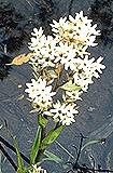 |
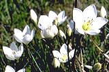
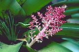
Tasmanian alpine and sub-alpine flora.
Gentianella diemensis (left top), near the Walls of Jerusalem
Milligania densiflora (right) on Mt Ossa
Richea pandanifolia (left bottom) in Palm Valley.
Select a thumbnail image or highlighted name for a higher resolution image (55k, 52k and 29k).
Photos: Harry Loots
|
 |
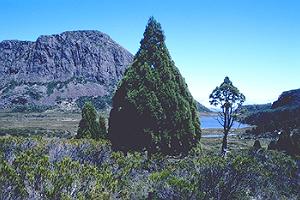
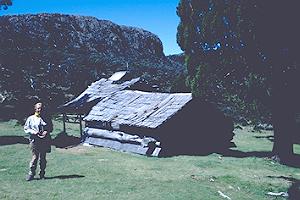
We found an enchanted world filled with many botanical wonders. Alpine vegetation that is slow to grow but easily destroyed has not been disturbed by fire or man. We walked through large ancient forests of Pencil Pines (Athrotaxis cupressoides) in the Walls of Jerusalem. One of the largest remaining Pencil Pine forests is on the southern wet slopes of The Temple. Duck-boards now protect the soggy track as it winds its way down from Damascus Gate to Dixon's Kingdom Hut. Elsewhere these forests have been burnt out or died when introduced soil fungus (Phytophthora cinnamomi) has attacked their roots. Fungus can be fatal to these water loving pines.
Some of the pines are over 1,000 years old. The oldest have thick trunks above their root systems. In exposed situations a horizontal spread of lateral trunks usually sprout from the central trunks and a mini forest of up to 25 metres in diameter appears as erect trunks grow from these horizontals. These are typically very short forests but in more protected situations Pencil Pines may grow to a height of 18 metres. Unfortunately some of these pines have been felled. In the l930s, trapper and later grazier Reg Dixon built a simple hut out of pine logs on the edge of the forest. Dixon's Kingdom Hut, as it came to be known, was renovated in the l960s for the filming of the movie The Tale of Ruby Rose. My memory of this film about a trapper's life in the Tasmanian Highlands is of storms with attendant strong winds and snow which enveloped this hut dwarfed by the mountain and its forest.
Further along the track on Mayfield Flats between Junction Lake and Lake Meston we came upon extraordinary large mounds of sphagnum moss. Mayfield Flats is an ice scrapped flat boggy area. Here moss has grown over hundreds of years into round light green to yellow furry hillocks up to 50 metres across and a metre and a half high. These are the genesis of dry islands that will support plants needing well drained soil in a sea of soggy peat bog.
We encountered the wildest country in the Never Never as we walked down the Mersey River. The track was difficult to follow. After descending into the valley next to the 20 metre high Clarke Falls we had the choice of walking along an overgrown river bank, through thick scrub on the river flats, through button grass where the track became a quagmire or through a rainforest that was a wet log jam. We made reasonable progress until we had passed McCoy Falls where we lost the track completely. I found out later that we were supposed to proceed through the rainforest next to the river. But the rainforest was very unappealing. It was a dark maze of large fallen logs covered with moss and various types of slime. Copious layers of leaf litter and dark shadows obscured any pad which may have existed.
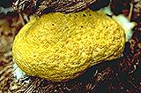 |
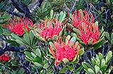
Jelly fungus, (Tremiscus sp.) (top) and Tasmanian waratah, (Telopea truncata (bottom).
Select the thumbnail image or highlighted name for a higher resolution image (45k and 67k).
Photos: Harry Loots
|  |
To escape the hard slog of the rainforest we climbed the valley side into a tall eucalypt forest. Higher up, the fallen logs were even larger than those below and more difficult to pass because of the steepness of the valley's walls. At least it was brighter after the darkness of the rainforest and the sunshine raised our spirits. A thick litter of fallen branches, leaves and bark covered the ground to knee height. Each step was a giant step to get through this thick mulch. There was no evidence of fire and the trees were enormous. Those on the ground had been blown over, split apart at the base, to form massive rotting timbers decomposing with yellow fungi oozing from their sides. This is an old growth forest but we did not realise how old until we had to pass a stand of waratah (Telopea truncata). These plants usually grow as two metre high shrubs. Here the waratahs were 10 metres high with half metre thick trunks. We could not imagine the age of these "shrubs" grown into trees but they were yet another obstacle to our progress which had been intolerably slow. We descended back to the rainforest along a ridge formed by the valley's intersection with Campfire Creek. Although we had smeared on layers of "Aeroguard" to all exposed skin our lunch by the creek was cut short by the discomfort of mosquitoes buzzing around our ears. We soon found the track running along a boundary between button grass and two metre high Melaleuca scrub. Then "bang". Quite suddenly we had come across duckboards. We were back in "civilization". At Hartnett Falls we were on the Overland Track with its 100 walkers a day population. That evening we camped with twenty others at Kia Ora Hut. Our time alone was over.
From the June 1998 issue of the newsletter of the Harbourside Group of the Australian Plants Society (NSW).
All photographs by Harry Loots.

[Front Page] [Features] [Departments] [Society Home] [Subscribe]
Australian Plants online - March 2000
Association of Societies for Growing Australian Plants
|